AQUEDUCT Floods
Aqueduct Floods is an interactive tool by WRI that maps current and projected riverine and coastal flood risk globally. It enables users to assess exposure, urban damage, and economic impacts under different climate scenarios, supporting risk analysis, resilience planning, and investment decision-making at country and sub-national levels.
Please login or join for free to read more.
OVERVIEW
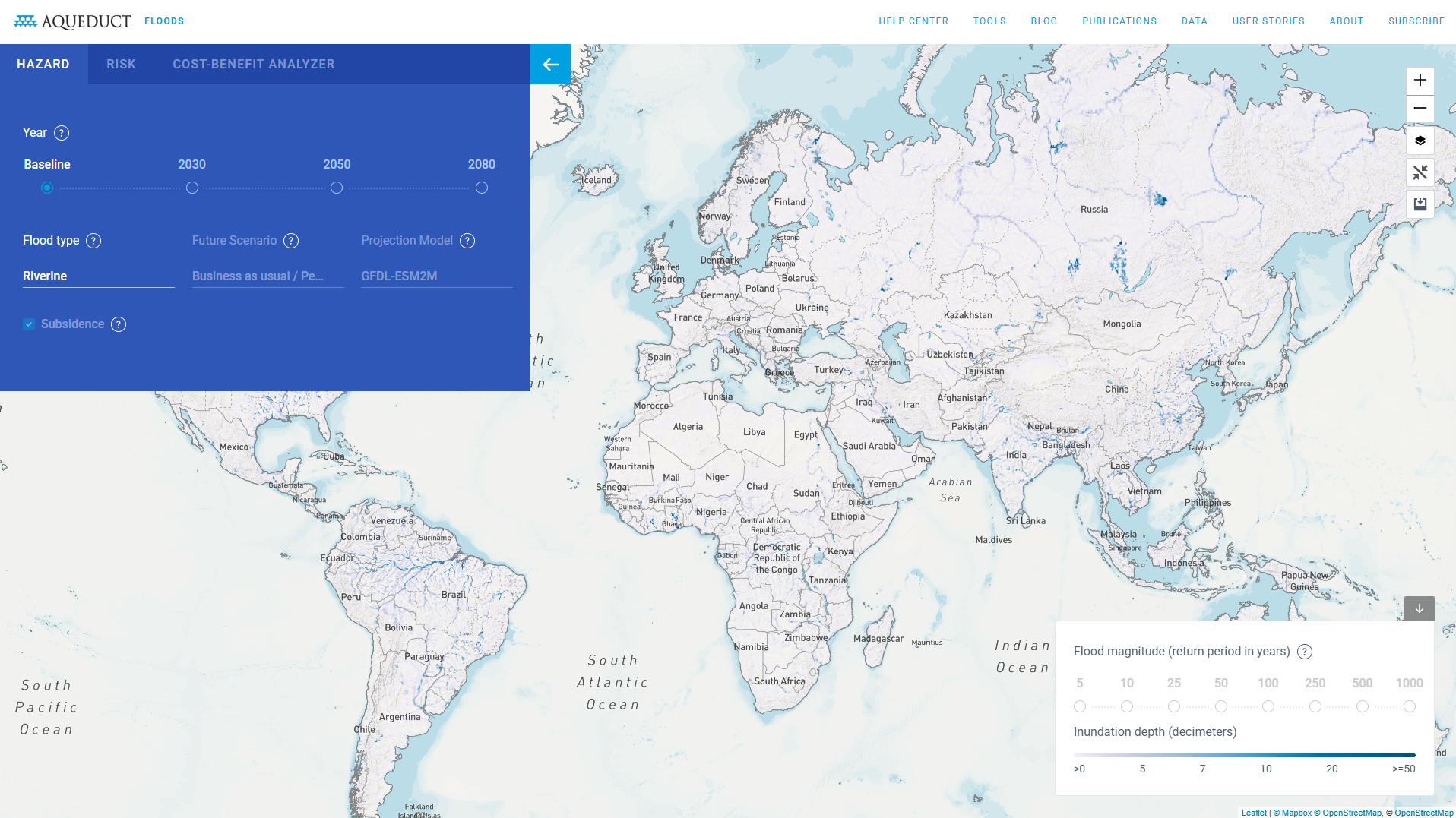
Aqueduct Floods is an interactive geospatial tool that assesses riverine and coastal flood risk worldwide under current and future climate scenarios. It enables users to explore physical flood hazards, exposure and potential economic damages at national and sub-national levels. The tool supports scenario analysis, including different climate pathways and socio-economic assumptions. Finance professionals may use it to inform climate risk assessment, resilience planning and long-term investment decisions.
Organisation behind the tool
Aqueduct Floods is developed and maintained by the World Resources Institute (WRI), a global research organisation focused on environment and development. It forms part of WRI’s broader Aqueduct platform, which includes water risk and coastal risk tools. The tool draws on climate models, hydrological data and socio-economic datasets developed in collaboration with research partners.
What the tool does
- Maps riverine and coastal flood hazard globally.
- Provides current baseline risk and future projections under different climate scenarios (e.g. RCP pathways).
- Allows users to adjust assumptions, including return periods and socio-economic scenarios.
- Estimates exposure of population, urban assets and GDP to flood events.
- Quantifies potential urban damage and economic losses.
- Enables comparison across countries, river basins and sub-national administrative units.
- Offers downloadable data outputs for further analysis.
- Includes a cost–benefit analysis module to assess adaptation measures and protection levels over time.
Target audience
The primary users are policymakers, planners and development practitioners assessing climate and disaster risk.
Other users include finance professionals, infrastructure developers, insurers, researchers and multilateral institutions. The tool is also accessible to the general public with an interest in climate risk.
Relevance to finance professionals
- Risk assessment – Identifies physical flood exposure of assets, supply chains and portfolios under current and future climate conditions. Supports stress testing and scenario analysis aligned with climate risk frameworks.
- ESG analysis – Provides environmental risk metrics relevant to climate-related disclosures and reporting, including exposure to extreme weather hazards.
- Market and infrastructure insights – Assesses flood vulnerability affecting urban infrastructure, transport, water systems and real estate markets.
- Investment context – Informs long-term capital allocation by highlighting regions with rising physical climate risk and by evaluating the economic case for adaptation investments.
- Insurance and credit analysis – Supports pricing and underwriting considerations by identifying areas of concentrated flood risk and potential economic loss.
Aqueduct Floods provides structured, scenario-based flood risk data that can be integrated into climate risk management, portfolio analysis and sustainable finance decision-making processes.

